by plonkit.net + r/geoguessr community
Two random-draw cards on top - one tip from plonkit.net (5,278 tips · 137 countries), one from the r/geoguessr wiki (146 tips · 24 topics). Then a Field Manual of two visual hunts: study a single photograph and write what you spot, or find the named country among nine decoys.
tags: geoguessr, geography, plonkit, reddit, field manual, random
GeoGuessr · Plonkit · a random tip from a random country
Click the button. Learn one thing about somewhere in the world. Each card is drawn at random from plonkit.net - a community-maintained GeoGuessr field manual covering 137 countries and 5,278 identification clues.
I. Plonkit · country tips
II. r/geoguessr wiki · collaborative threads
A second source: the country / region guides curated in the r/geoguessr wiki. Each card is a discrete tip drawn from either the original post body or one of the top comments on these threads - 146 tips across 24 topics (countries: Argentina, Turkey, Japan, Russia, Sweden, Andorra, Indonesia, etc; regions: Norway/Sweden/Finland, Germany/Austria/Switzerland; topical: Cyrillic scripts, Africa flowchart, road-curve chevrons, "Chad" moves, language tips).
III. The Quiz · four-option flashcards
A photo. Country tag hidden. Four buttons. Pick. Wrong choices go red, right one green; tip body reveals. Decoys are seeded from the tip-id, so a re-encountered card always shows the same four choices - no learning by elimination across sessions. Keyboard: 1–4 to pick, Enter for the next card.
Hide the country. Pick the country.
IV. Deep Dive · one country end-to-end
Pick a country. Walk through every plonkit tip in its publication order - Step 1, Step 2, Step 3, Step 4. Mark each mastered or review later. The marks persist; next visit resumes where you left off.
Pick a country. Walk every tip in order.
V. Confusions · 14 look-alike pairs
Sweden vs. Finland. Argentina vs. Chile. Fourteen famous look-alikes that decide tournament rounds, each with a discriminating cue + a two-country mini-quiz. Scores persist per pair.
Sweden vs. Finland. Argentina vs. Chile.
VI. The Meta · cross-category flashcards
Where the per-country cards above ask “what's this place?” these turn the lens 90°: pick one clue type - bollards, road lines, license plates, post boxes, follow cars, utility poles, sceneries, rifts, flora, architecture - and study its variation across every country. Fifteen thousand cards merged from Geometas, GeoHints, and Plonkit's Beginners Guide. Filter by source, category, or country.
VII. Regional learning guides
Geometas's curated /learn/<region> tracks - nine regional pedagogies (Latin America, Nordics, Baltics, Eastern Europe, South East Asia, Central Africa, South African Countries, Australia / New Zealand, plus the cross-cutting common locations guide). Read in order: first impressions → license plates → milestones → signposts → poles. The right way to enter a region you don't know.
Read the region before you draw the card
Australia vs. New Zealand
↗ on geometas.com01Bollards
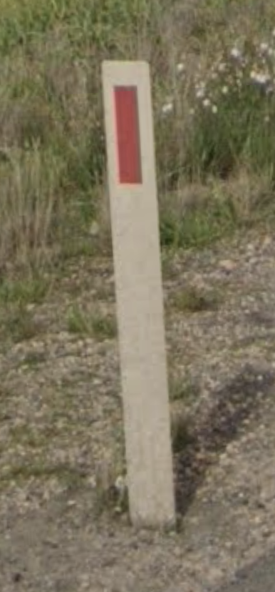
🇦🇺 Australia
In Australia, bollards are typically white, featuring a red reflector on the front and a grey reflector on the back. Note that on some Australian bollards the red reflector is circular, not rectangular.
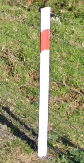
🇳🇿 New Zealand
In New Zealand, bollards have a red strip around the upper part of the bollard.
02Give-way signs
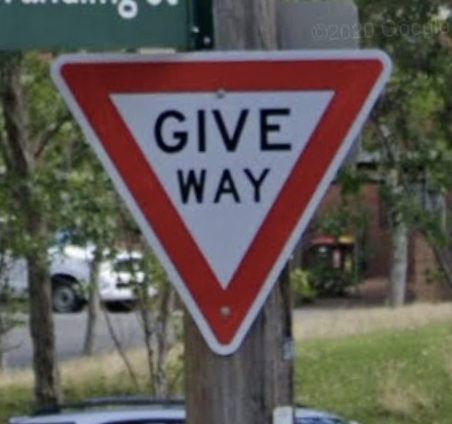
🇦🇺 Australia
Australian give-way signs are written in black writing.
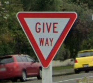
🇳🇿 New Zealand
In New Zealand, give-way signs have red text.
03Soeed signs
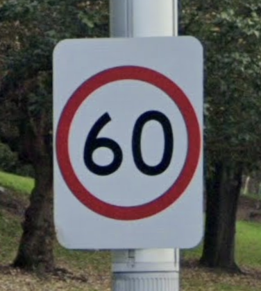
🇦🇺 Australia
Australian speed limit signs appear on a white rectangle. This contrasts New Zealand speed limit signs which appear as a circular cut-out.
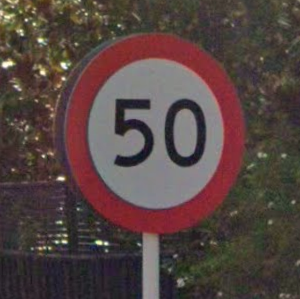
🇳🇿 New Zealand
In New Zealand, speed signs are typically circular.
04Street name signs
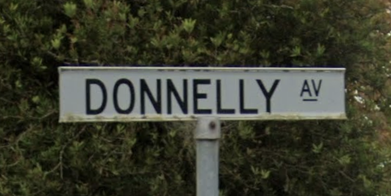
🇦🇺 Australia
Australia typically has white street signs.
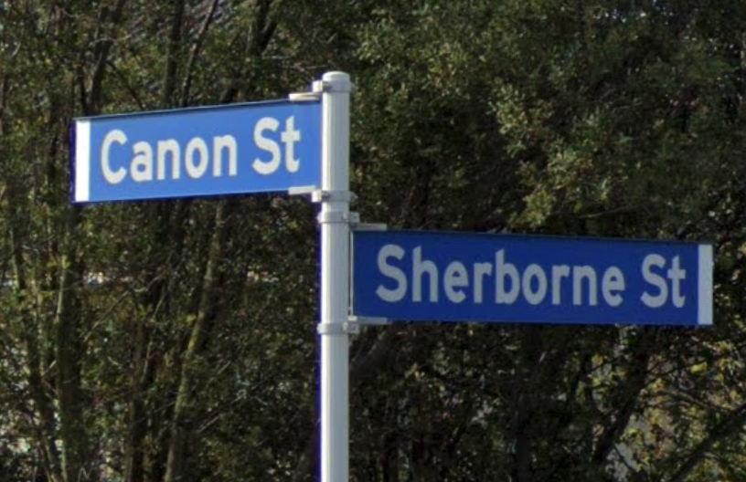
🇳🇿 New Zealand
New Zealand street signs are blue or green.
05Chevrons
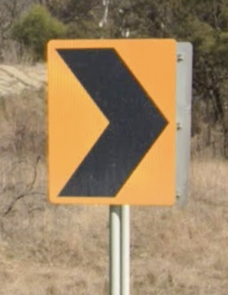
🇦🇺 Australia
Australia uses black-on-yellow chevrons without a border around them. White-on-black chevrons also exist.
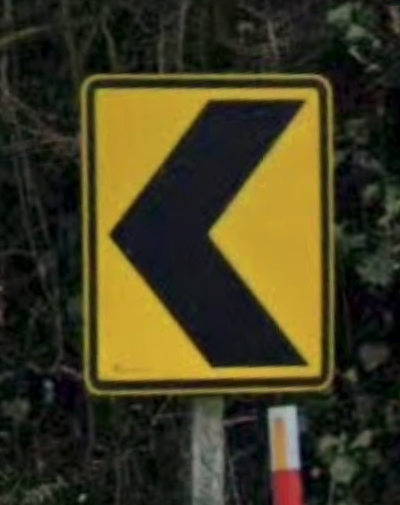
🇳🇿 New Zealand
Chevrons in New Zealand are black-on-white colored with a black outline.
06Flora
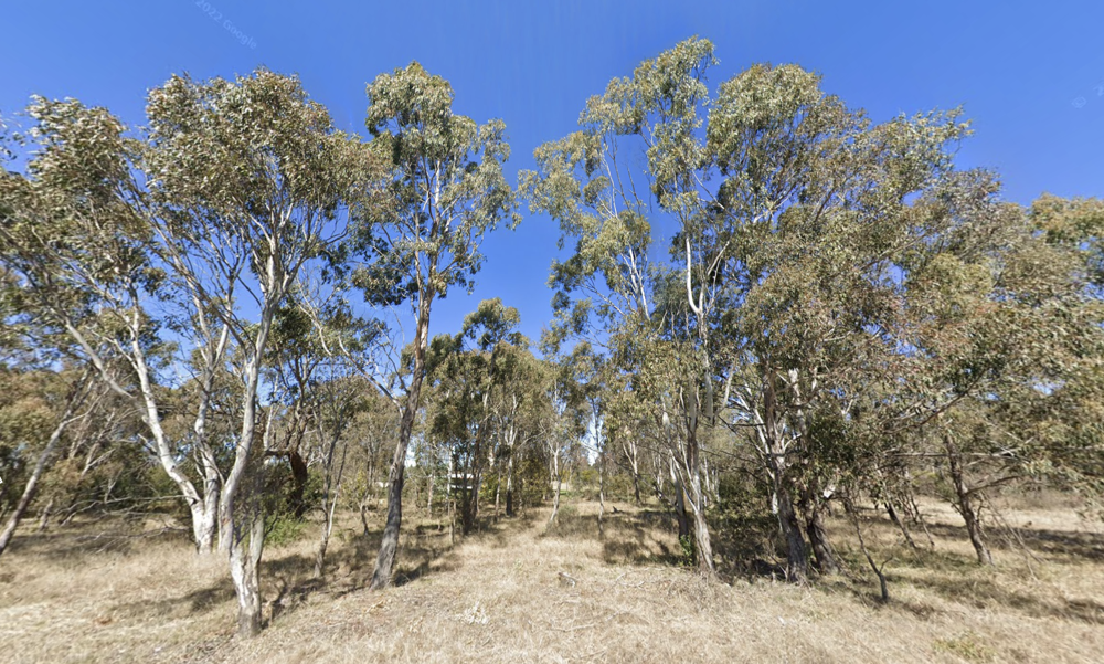
🇦🇺 Australia
In Australia, Eucalyptus trees are a prominent feature, typically tall with white bark.
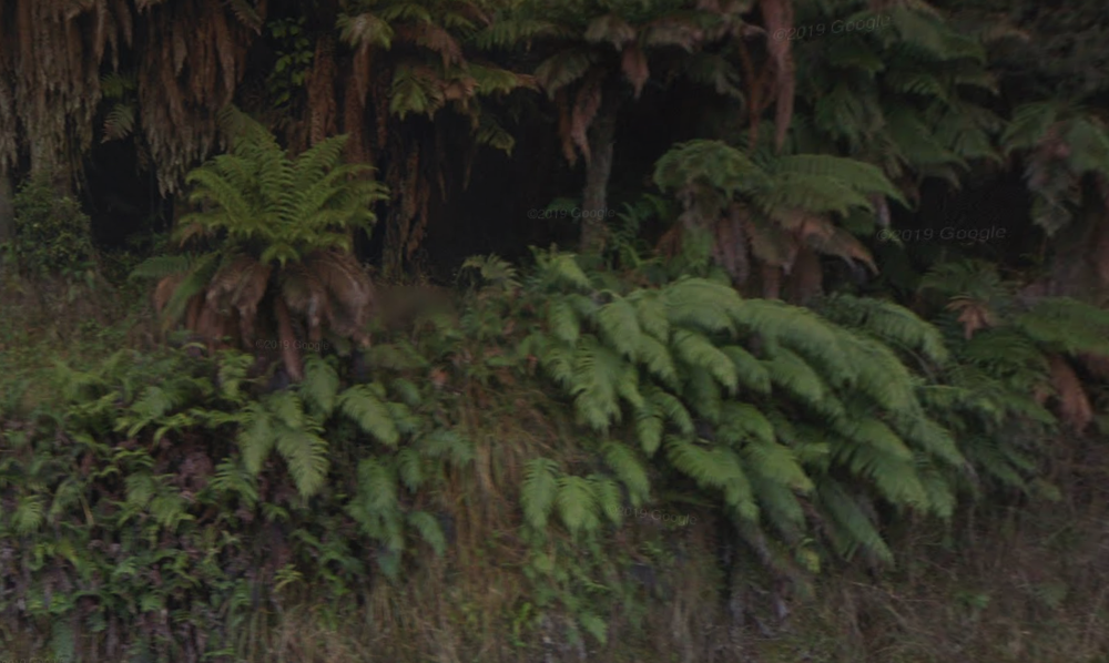
🇳🇿 New Zealand
It's common to see fern growing in forested areas in New Zealand.
07Other 🇳🇿 New Zealand clues
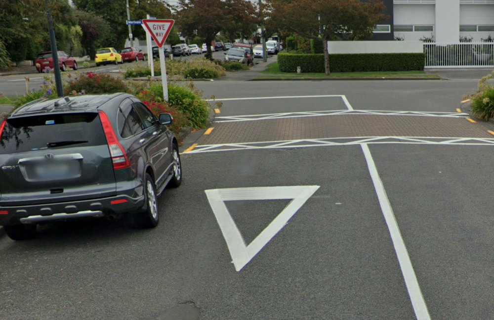
Give-way street marking
In New Zealand many give-way intersections also have a white give-way triangle painted on the street.
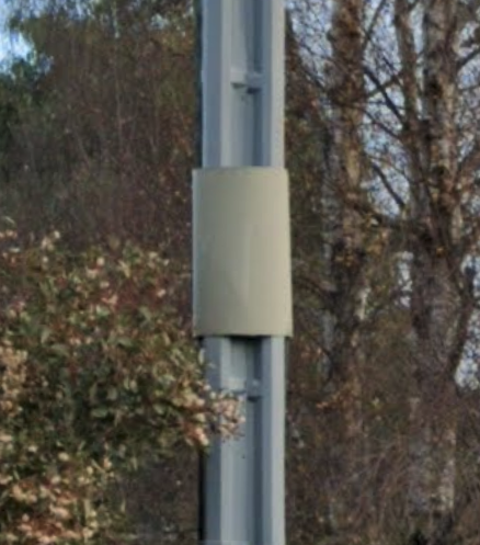
Silver pole wrapping
In New Zealand, most utility poles have a lone piece of metal, usually silver or white, wrapping around them. Note that the Australian state of Tasmania also has pole wrappings, but they are usually olive green.
VIII. The four undercovered axes
Plonkit, GeoHints, Geometas all lean infrastructure. Four cue types that decide rounds when they appear and that nobody has catalogued systematically - traditional dress, sky and atmosphere, soil colour, visible wildlife. Original. Refined over time. Each cue lists what to look for, the countries it points to, and when it actually surfaces in Street View.
The cues no one else has indexed
Plonkit, GeoHints, Geometas - they all lean infrastructure. Traditional dress, atmospheric sky, soil colour, and visible wildlife are decisive when they appear and almost nobody has catalogued them. This is the start of doing so.
Clothing & traditional dress
In modern Street View most people wear unmarked Western dress, so clothing is rarely the primary cue. But where it does appear, it is decisive. The cues below are the ones that survive into 2010s+ panos in their regions.
01Indigo robes and tagelmust head-wraps on men
MaliNigerMauritaniaAlgeriaTuareg dress. Indigo so deep it stains the skin. Sahel and Saharan strip; if the men in shot are wearing this, the haze and sand surrounding them are not generic - they are West African.
02Woolen poncho + bowler hat on women
BoliviaPeruEcuador (highlands)The bowler arrived with British railway workers in the 1920s and was adopted as Andean womenswear; pair with woven shawl carrying a child = highland Bolivia/Peru with near-certainty.
03White cotton dhoti + lungi on men
IndiaBangladeshSri LankaA wrap-skirt of plain or checked cotton, knot at the waist. The southern Indian states, rural Bangladesh, and Tamil regions of Sri Lanka are the bulk of where you'll see this in the wild.
04Saffron or maroon monk robes
ThailandMyanmarSri LankaBhutanTibetSaffron = Theravada (Thailand, Sri Lanka, Myanmar). Deep maroon = Vajrayana (Tibet, Bhutan, Mongolian Buddhism). The colour difference narrows by half within Buddhism.
05Black thobe + white headscarf with red-checked agal
Saudi ArabiaUAEKuwaitQatarGulf khaleeji dress. The red-and-white-checked shemagh is more common in Saudi Arabia and Jordan; pure white in the UAE and Qatar.
06Conical bamboo hat (nón lá)
Vietnamparts of southern ChinaCambodiaOutside the rural-Vietnam stereotype, you'll see it on market traders and rice farmers across the Mekong delta and into Yunnan. Less common in Thailand than people think.
07Embroidered colour-blocked dresses + multi-layered woolen skirts
Guatemalasouthern Mexico (Chiapas)BoliviaMayan huipil = Guatemala (especially highlands, Lake Atitlán) and Chiapas. The Bolivian version is heavier wool with the bowler.
08White full-length thawb on men, plain
Saudi ArabiaOmanYemenparts of the SahelPair with date palms and grey-paved roads = Gulf. Pair with sand-laterite road and donkeys = Sahel.
09Skirts in tartan plaid + heavy socks
ScotlandSpecifically at games / public events / outside churches; rare on the open road, but if you see it the call is automatic.
10Black wide-brimmed hats and black coats with peyot side-curls
Israelparts of NYCparts of AntwerpHaredi Jewish dress. The presence narrows by neighbourhood: Mea Shearim in Jerusalem, Williamsburg in Brooklyn, the Antwerp diamond district. If you see it in Street View, look at the script on shop signs to disambiguate.
11Bright red Maasai shuka tied over one shoulder
KenyaTanzaniaPlus tall, thin men with shaved heads and beaded earrings. Northern Tanzania and southern Kenya. Often photographed near savanna or cattle.
12Long pleated wrap skirt + striped cotton shirt + curved knife on the belt
BhutanThe gho (men) and kira (women). Mandatory in public buildings. If you see this in Street View - combined with prayer flags and the script - you are in Bhutan, no second guess.
IX. The rest of the road
The training a great player gets from plonkit alone is incomplete. The other wikis, the YouTube canon (Anto on poles is mandatory), the practice maps inside GeoGuessr, sister games, tools, the community Discords.
The curated link gallery
The training a great player gets from plonkit alone is incomplete. The other wikis, the YouTube canon, the practice maps inside GeoGuessr, the sister games, the tools, the community. Everything hand-checked.
Guides
The other big community references beyond plonkit. All cross-category, all worth reading cover to cover.
- Geometas ↗wiki
Visual flashcards organised by clue type - flora, poles, signposts, milestones, chevrons. The single best cross-category index.
- GeoHints ↗wiki
Architecture, bollards, camera generations, follow cars, post boxes, scenery types, rifts, utility poles. Built by Twitch streamers; listed in Bellingcat's OSINT toolkit.
- Plonkit · Beginners Guide ↗wiki
The bollards / road lines / license plates / language scripts primer. Read first, then drill the per-country pages.
- Geoguessr Note (dingyiyi) ↗notes
Personal training notes site with a strong vegetation section and per-country script tells. Concise.
- Reverse Image Location - Ultimate Meta Guide ↗article
Long-form 2026 single-article summary of the major metas. Good for binge-reading on a flight.
- GeoTips.net ↗wiki
Community wiki, lighter than plonkit. Useful for quick country lookups when plonkit is overwhelming.
YouTube · the canonical reference videos
Long-form videos that beat any article on their topic. Watch each one once with a notepad.
- Every Pole in GeoGuessr EXPLAINED! - Anto ↗video
~30 min, the canonical utility-pole video. Single most useful YouTube hour for a serious player.
- Rainbolt - channel ↗channel
The famous one. His tournament breakdowns are textbooks; "0.1 second locate" videos are showmanship but instructive.
- GeoWizard - channel ↗channel
Tom Davies. Geography long-form: the Mongol Rally, walking across countries in straight lines, deeper geography than pure GeoGuessr.
- Zi8gzag - channel ↗channel
Competitive player. Tutorials on specific country tells, breakdowns of his tournament rounds.
- Blooprint - channel ↗channel
Meta breakdowns, plus light-touch teaching of overlooked cues like soil colour, camera blur, antennas.
- Guide to Utility Poles Around the World ↗video
A second pole video - different angle from Anto's, useful complement.
Practice maps · inside GeoGuessr
The maps to actually play once you've been reading. Each link opens the map page on geoguessr.com.
- A Diverse World ↗map
The competitive standard. Curated coverage from every country, well-balanced. The map serious players train on.
- An Improbable World ↗map
Harder. Off-the-beaten-path coverage. After A Diverse World feels easy, come here.
- A Community World ↗map
Crowd-curated, varies in difficulty. Good when you want surprise.
- A Balanced World ↗map
Easier intro to country coverage. Use for warm-up rounds.
- A Pinpointable World ↗map
Every location has identifiable street signs or landmarks. Best for learning to read signs systematically.
- USA Pinpointable ↗map
For deep USA training. Every spot has enough information to nail the state, often the town.
Sister games · adjacent practice
Geography games that train the same muscles by a different route. Use when burnt out on Street View.
- Nature Guessr ↗game
Click the spot on the world map where this animal naturally lives. Daily challenge, ten animals. Trains the wildlife→country link no other tool covers.
- Seterra ↗game
Country, capital, flag, river flashcards. The boring foundation; do five minutes a day for a month.
- CityGuesser ↗game
Watch a short clip from a city, guess where. Sister-game to GeoGuessr; uses video instead of stills, different cues.
- Worldle ↗daily
Daily country-by-silhouette. Five-minute warm-up.
- Geogrid ↗daily
Daily 3×3 country grid puzzle. Fits a coffee break.
- Travle ↗daily
Get from country A to country B through neighbouring countries. Trains borders.
Tools
Things you keep open in a second tab while playing.
- GeoSpotter ↗tool
Drop a Street View URL, get a deconstruction of every visible clue. Great for post-game review.
- Geoguessr Map Maker ↗tool
Build your own training maps from any region you want to focus on.
- Plonkit Search ↗tool
Search the plonkit corpus by phrase. When you want to look up a specific clue you half-remember.
Community
Where the actual players are. Discords are where the highest-level trick-trading happens.
- r/geoguessr ↗forum
Reddit community. The wiki has more meta. Weekly improvement threads.
- GeoGuessr Discord ↗chat
The official Discord. Pinned references, country channels, ranked-match matchmaking.
- Plonk It Discord ↗chat
The plonkit community Discord. Where the wiki actually gets edited.
Tips, images, and the underlying field-craft belong to the open community: plonkit.net, r/geoguessr, geometas.com, geohints.com, and the individual creators credited in each card. The undercovered-axes section is original to this site and is built from primary observation; it will sharpen with use.